-
 Community Experiences on Indigenous Seed Sovereignty & Seed Savers Rights
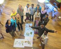
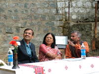
 The document outlines vital discussions from the Community Experiences on Indigenous Seed Sovereignty, focusing on rights, conservation, and challenges faced by indigenous farming communities. It highlights that India’s national genetic resources exceed 400,000 accessions across 1586 species, with significant varieties also stored globally. The text underscores the inadequacies of existing laws, such as the PPVFR Act and the National Seed Policy, which may undermine community rights over traditional seeds. It calls for stronger networks and governmental support to safeguard biodiversity against privatization and genetic manipulation, emphasizing the need for an open-source National Biodiversity Heritage Registry to protect collective heritage.
-
 Seed Sovereignty and Indigenous Futures
 This report presents a critical analysis of seed sovereignty among Indigenous and Adivasi communities in India, focusing on the threats posed by corporatisation, state policy, and climate change. Drawing from recent research, fieldwork, and ongoing projects such as the RLS–Keystone initiative, it outlines the contours of seed systems shaped by history, global power structures, and community resistance. Anchored in agroecological and rights-based perspectives, this report is intended as a policy advocacy document for national and international forums.
-
 Annual Report _2023-2024
 This resource contains an overview of activities taken up during the course of FY 2022-23 at Keystone Foundation, inclusive of programmatic activities, finances and updates from the field centres
-
 Annual Report _2022-2023
 This resource contains an overview of activities taken up during the course of FY 2022-23 at Keystone Foundation, inclusive of programmatic activities, finances and updates from the field centres
-
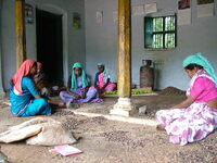
 Seeds of Hope & Food for Future
 Since 2000s, work on documenting and reviving the organic natural farming of millets and vegetables, land development and traditional
agricultural practices have been taken up. The millet revival efforts started along the north-eastern slopes of Nilgiris. The rich agro-diversity
contributes to the nutritional and food security of the indigenous communities in the region and Keystone’s efforts have been towards
encouraging locally sourced cultivated and uncultivated produce, that communities have immense knowledge of. Over the years, forest an
agricultural species have been saved in seed banks at Keystone’s office and various field centres.
-
 Commissioning the Nilgiri Field Learning Centre(NFLC)
 Launched in 2015, the Nilgiri Field Learning Centre is a collaboration between Keystone Foundation and Cornell University, born from the idea of
a “field school.” Each semester blends bilingual, place-based learning with fieldwork across themes like Indigenous worldviews, ecology,
governance and health. Bringing together Cornell students, Keystone practitioners and Adivasi students, the NFLC has shaped research,
expanded Keystone’s programs, and influenced teaching and scholarship across both institutions.
-
 Radio Kotagiri goes on air
 In 2013, Radio Kotagiri 90.4 MHz became the Nilgiris’ first community radio station, broadcasting across a 15 km radius and amplifying voices of
women, children, tea workers, farmers, migrants and Indigenous communities. It has played a key role in public awareness, from COVID-19
communication to programmes on biodiversity, livelihoods and social issues. Supported by volunteers and collaborators, the station builds local
media skills and strengthens community-led storytelling across the Biosphere Reserve.
-
 Field Guides of Forest Plants and Honey Trails in the Blue Mountains
 Publishing posters, books, field guides of what the Keystone team observed and recorded during field work in the Nilgiri biosphere reserVe. The
field diaries of sociologists, economists, ecologists, gave way to numerous publications and knowledge products which have become
foundational in shaping Keystone’s work.
-
 Happy Valley Restoration-Wetlands and Sholas
 Initiated in 2006, Happy Valley was one of Keystone Foundation’s earliest ecological restoration efforts, located just below the Kotagiri campus.
Once overrun by invasive species such as Cestrum, Solanum and Lantana, the valley was revived through community support and the planting
of 400 saplings covering 26 native shola species. Today, this restored patch has grown into a thriving forest, enriching biodiversity and strengthening the water sources vital to Kotagiri town.
-
 India’s first Bee Museum
 In 2006, Keystone Foundation opened India’s first Bee Museum in Ooty. This was a unique space celebrating native bees and the Indigenous
communities who live alongside them. Inaugurated by Meena Gupta, then Secretary of Tribal Affairs, and marked by a surprise visit from two
wild Apis dorsata colonies, the museum blended art, exhibits, and children’s activities to spark appreciation for local pollinators. Though it closed
after the pandemic, its influence continues to inspire.
-
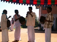 Hubba becomes a way of sharing and celebrating
 A first festival or hubba was held on 9th August 2005 on International Day of Indigenous Peoples, honoring the rich cultures of Nilgiri
communities. Subsequently a honey festival or Jenu Hubba was held, followed by one on traditional ancestral boundaries. What began on the
Kotagiri campus now thrives across Keystone’s field centres in the Nilgiri Biosphere Reserve, keeping traditions alive through song, dance, food,
and collective celebration, themes that are important to indigenous identities.
-
 A newspaper for, by and of the Indigenous People
 In 2003, Kota, Kurumba, Irula and Toda community members decided they needed a way to share news across the Upper Nilgiris. Their
consultation led to Nilgiri Seemai Suddhi, the region’s first Indigenous newspaper, created by community journalists. Printed quarterly and
distributed to 235 villages, it covered festivals, livelihoods, public services and local needs, prompting timely government responses and giving
tribal voices a powerful platform for collective action.
-
 Forest surveys and studying honeybees in the wild,
 Through the “Bees, Biodiversity and Livelihoods” project, Keystone conducted extensive studies on bees in the wild. NTFP resource assessments
across the Nilgiri Biosphere Reserve helped us understand the forest types. Using mixed social–ecological methods, surveys began with
community mapping and ground-truthing walks that revealed the richness of wild foods, medicinal plants and sacred species. These findings
guided the placement of value-addition units, strengthened local biodiversity knowledge, and generated field guides, datasets and research
that continue to inform community action.
-
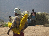
 NTFP value addition centers take shape
 Keystone’s early work with Non timber forest produce (NTFP) lead to the setting up of village production centres in Semmanarai,
Banglapdigai and Burliar. What began with fair pricing and simple processing soon expanded into tribal-owned units where women gained
skills, elders shared traditions, and forest produce was valued at its source. This grassroots effort now sustains over 4,500 indigenous food
producers across the Nilgiris.
-
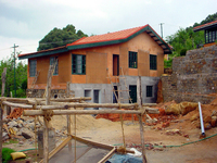 Rammed earth building construction begins
 Architects from Auroville were contracted for the project. Here’s what Anupama Kundoo, chief architect has to say: “The architecture of the
campus began in 2000 with a site plan of small detached buildings. The site of the initial buildings on the very steep but narrow site, was an
opportunity to build a campus of small separate buildings rather than a large institutional looking one. This strategy gave the campus a less
intimidating look and integrating into the local context, giving out a strong message of development with low environmental impact.”
-
 An office and a Green Shop open in kotagiri
 After travelling the length and breadth of Tamil Nadu, a decision was taken to set up office in Kotagiri in 1995 and to be a field based organization.
Discussions with honey hunters, forest produce collectors and traditional millet growers lead to the linking of conservation, enterprise and
livelihoods. In 1997, Keystone opened a small but significant outlet—the first Green Shop in Kotagiri, thereby bringing wild honey and traditional
millets directly to people.
-
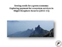 Sowing seeds for a green economy Exploring payment for ecosystem services in Nilgiri Biosphere Reserve
 The project "Sowing Seeds for a Green Economy" in the Nilgiri Biosphere Reserve explores Payment for Ecosystem Services (PES) as a way to align investments in environmental and human well-being. PES involves voluntary transactions where service providers secure ecosystem services for buyers, focusing on conditions like continuous service provision and rewarding additional efforts. The initiative aims to profile selected sites, implement pilot projects on water, pollination, and non-timber forest products (NTFPs), and advocate for policy collaboration across regional governments. Preliminary outcomes suggest positive impacts on water management, NTFP valuation, and pollinator habitat assessments, with future efforts geared towards engaging stakeholders and integrating PES with climate finance.
-
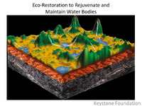 Water Bodies Rejuvenation
 Keystone Foundation is focused on the eco-restoration of water bodies in the Nilgiris, addressing critical but overlooked resources like springs and wetlands. They have inventoried 300 springs and over 300 wells, revealing a water crisis affecting towns and rural areas despite the district being classified as water surplus. Their studies highlight drying springs and conflicts over water between communities and wildlife. They emphasize the importance of monitoring water quality and levels, conducting natural resource management studies, and exploring innovative solutions like floating wetland islands for water purification and habitat restoration.
-
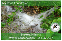 Namma Nilgiris Water Conservation
 Keystone Foundation, active since 1995 in the Nilgiri Biosphere Reserve, focuses on conservation and ecological restoration, emphasizing the importance of springs and wetlands as vital water sources. It has initiated projects through partnerships like the Aadhimalai Pazhangudiyinar Producer Company and established the first community radio in the region, Radio Kotagiri. The foundation has inventoried various springs and wells and addresses threats to wetlands from invasive species while promoting sustainable management of these resources. Their work aims to enhance local livelihoods and preserve the unique ecology of the Nilgiris.
-
 Impact of Coal Mining on Water Resources
 Coal mining is vital for economic growth, particularly in developing countries like India, where its consumption has surged significantly over the decades. However, the environmental repercussions are substantial, affecting land, water, air, and biodiversity. Mining practices—especially open-cast methods—cause severe land degradation, water pollution, and air quality deterioration. Additionally, coal mining poses health risks to workers and disrupts local communities. To mitigate these impacts, effective environmental management policies and land reclamation strategies are essential. Future energy strategies should prioritize renewable sources to balance economic needs with ecological preservation.
-
 The National Academia Conclave on Urban Sanitation
 The National Academia Conclave on Urban Sanitation, held at CEPT University from March 9-10, 2019, focused on advancing knowledge and practices in non-networked sanitation through collaboration among academic institutions. The event aimed to integrate urban sanitation into educational curricula, enhancing training for students and professionals. Key activities included discussions on sanitation challenges, capacity building workshops, and sharing best practices among 45-50 faculty members and over 100 students from various universities. The conclave underscored the need for decentralized sanitation solutions and aimed to foster cross-learning and innovation to improve urban sanitation in India.
-
 Safe disposal and Incinerators
 The guide outlines essential factors for selecting incinerators for disposing of sanitary napkins in schools, highlighting the importance of efficiency, emission control, and maintenance. Two main types of incinerators are discussed: manually operated fire-based and electric models, with varying capacities and costs. Key considerations include the collection frequency of used materials, construction quality, operator training, and safety measures. Additionally, alternative disposal methods like deep burial and composting are mentioned, noting their advantages and limitations. Overall, the emphasis is on ensuring hygienic, effective waste management while adhering to safety and environmental standards.
-
 Faecal Sludge and Septage Management Policy and Operational Guidelines
 The Greater Visakhapatnam Municipal Corporation has established a Faecal Sludge and Septage Management Policy to enhance sanitation and public health in the city, supported by USAID and WSUP Advisory. The policy focuses on effective management of faecal sludge through improved treatment, transport, and disposal practices, aiming for universal sanitation coverage. It outlines operational guidelines, emphasizes community engagement, and integrates financial sustainability to ensure long-term service viability. The initiative aligns with national sanitation goals, promoting cleaner environments and reducing health risks, particularly for low-income populations reliant on onsite sanitation systems.
-
 Guide to Septage Treatment and Disposal
 The "EPA Guide to Septage Treatment and Disposal" serves as a practical resource for managing the handling, treatment, and disposal of domestic septage. It outlines the roles and responsibilities of administrators, inspectors, haulers, and facility operators, emphasizing the importance of regulatory compliance and effective management to safeguard public health and the environment. The guide discusses various treatment options, including land application, treatment at wastewater treatment plants (WWTPs), and independent facilities, while noting the challenges posed by septage characteristics. It also highlights the need for odor control measures and provides guidelines for developing a successful septage management program.
-
 GLASS RECYCLING IN INDIA
 The seminar on glass recycling in India highlighted the importance of reducing, reusing, and recycling glass to manage waste effectively. Key challenges include lack of public awareness, inadequate infrastructure, and primitive waste collection methods. The glass industry must take the lead in educating citizens and collaborating with government and NGOs to enhance recycling efforts. Successful examples from countries like Germany emphasize the need for strict regulations and responsible packaging practices. The seminar urged the industry to advocate for improved facilities and support for recycled materials, aiming to boost the recycling rate and reduce environmental impact.
