-
 Spring profile report_ SIKKIM
 The ACWADAM report highlights the critical water shortage faced by higher-elevation hamlets in Sikkim, particularly during droughts when springs dry up. It emphasizes the need for effective springwater management, especially given the evidence of depletion due to lifestyle changes and climate impacts. The report details the training of field facilitators on spring identification and recharge techniques, showcasing various springs like Chukudum, Lampatey, and Devithan, which illustrate the hydrogeological complexities involved. The Dhara-Vikas program is presented as a promising strategy to enhance aquifer recharge and revive diminishing water resources, including hilltop lakes.
-
 Sindhupalchok Spring hydrogeology, Nepal
 The technical report on Sindhupalchok's hydrogeology highlights the region's complex geology, featuring schists and gneisses, and the impact of recent earthquakes on spring behavior. The study identified six springs and assessed their recharge areas, noting that many springs have dried up or changed due to geological disturbances. Recommendations include implementing staggered contour trenching and vegetation planting to enhance groundwater recharge, particularly in areas used for agriculture. Overall, Sindhupalchok has significant groundwater resources, necessitating effective management and awareness to maintain sustainability amid environmental changes.
-
 Scientific and Technical inputs to spring shed management
 The project aims to improve spring water management in five districts of Nagaland, addressing the region's critical water scarcity issues exacerbated by climate change and land use. Collaborating with local organizations, the initiative focuses on providing secure drinking water, conducting springshed surveys, and educating communities on hydrogeology. Key objectives include identifying recharge zones, building local capacity for spring protection, and advocating for spring-specific policies. The study also highlights the need for a sustainable approach to water management, ensuring the preservation of traditional water sources while adapting to changing environmental conditions.
-
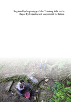 Regional hydrogeology of the Tendong Hills and a rapid hydrogeological assessment for Kitam
 The report discusses the complex hydrogeological dynamics of the Tendong Hills and Kitam area in Sikkim, highlighting the interplay of diverse rock types and structures that influence the region's aquifers and spring systems. It emphasizes the importance of incorporating geological insights into watershed and spring development programs to enhance water security, especially in light of climate change and human activities. ACWADAM is actively involved in developing hydrogeologically informed recharge strategies for springs in these areas, aiming to improve water management and community capacity building. The report also outlines specific recharge areas and spring characteristics, underscoring the need for careful monitoring and management to ensure sustainable water supply.
-
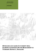 HYDROGEOLOGY BASED CATCHMENT AREA PLANNING FOR SPRING WATER MANAGEMENT IN TUENSANG DISTRICT , NAGALAND
 The ACWADAM report outlines a hydrogeological assessment aimed at managing spring water resources in Tuensang district, Nagaland. It highlights the critical state of freshwater availability due to population growth and environmental changes, emphasizing the need for effective groundwater conservation strategies. The study involves mapping spring locations, monitoring discharge, identifying recharge areas, and developing hydrogeological layouts. It suggests action-oriented measures like constructing recharge pits and trenches while promoting community involvement in groundwater management. Ultimately, the report advocates for sustainable practices to protect water resources and enhance local water supply systems.
-
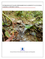 Hydrogeology based spring shed management plan in Khar, Nepal
 The report presents a hydrogeology-based management plan for springs in Khar, Darchula District, Nepal, focusing on the Dallekh-Sundamunda springshed. It identifies 48 springs, emphasizing their dependence on geological features, such as slates and fractures, for groundwater movement and accumulation. To enhance water availability, the report recommends targeted recharge measures, like constructing contour trenches and check-dams, particularly in areas with dense vegetation and agricultural land. The study highlights the need for ongoing data collection, geological assessments of additional springs, and training local residents in groundwater management practices.
-
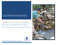 Hydrogeological assessment of Tendong Hills Region
 The report by ACWADAM outlines the hydrogeological assessment of the Tendong Hill region in South Sikkim, as part of the Village Water Security Plan (VWSP) development project in collaboration with RMDD and GIZ. It highlights the intricate relationship between the diverse rock types and structures in the Himalayas and their impact on the hydrogeological environment. The assessment reveals that the local aquifers are often discontinuous and can vary significantly in size and discharge, leading to challenges in water management for surrounding villages. Additionally, the report emphasizes that existing watershed development programs often overlook geological factors, risking project efficacy and sustainability.
Key findings from the assessment indicate that springs in the Tendong Hills are primarily influenced by geological structures, including faults and fractures that dictate spring locations and discharge behaviors. The study identifies crucial recharge areas for these springs and underscores the necessity of integrating geological insights into water management strategies. ACWADAM's efforts include monitoring spring discharge and water quality, along with community capacity building for better management practices. The Dhara Vikas project, which aims to conserve springs, relies on ACWADAM's hydrogeological expertise to inform its methodologies.
In conclusion, the report suggests a regional implementation plan to enhance water security in the Tendong Hill area, particularly for villages facing water scarcity. The proposed VWSP will address specific village needs while incorporating a holistic understanding of the local hydrogeological context. By engaging local communities and leveraging scientific research, the project aims to create sustainable water management practices that are resilient to both climatic and anthropogenic pressures, ultimately fostering greater water security for the region's inhabitants.
-
 Hydrogeological assessment of Demul and Chicham, Spiti
 The hydrogeological assessment of Demul and Chicham villages in the Spiti Valley, Himachal Pradesh, highlights significant challenges related to water sources amidst climate change impacts. Springs serve as the primary water supply for local communities, providing essential drinking and irrigation water. However, the region has seen a decline in spring discharge due to changes in precipitation patterns, particularly reduced snowfall. This situation has raised concerns about sustainable livelihoods in these villages, prompting an initiative by Ecosphere and ACWADAM to identify potential recharge areas for aquifers that feed these vital springs.
The study documented over ten springs in both villages, with water quality testing indicating varying levels of Total Dissolved Solids (TDS) and salinity. While some springs met drinking water standards, others showed elevated pH levels, necessitating further investigation into potential contamination sources. The report suggests implementing recharge structures, such as trenches and percolation pits, in identified recharge zones to enhance groundwater levels. These efforts aim to mitigate the adverse effects of climate change on water availability, ensuring that local communities can maintain their livelihoods in an increasingly unpredictable environment.
In conclusion, the delicate ecosystems in the Spiti Valley are facing mounting pressure from climate change, leading to a water crisis that threatens the sustainability of Demul and Chicham villages. With changing snowfall patterns and rising temperatures, proactive measures are essential to secure water supplies through innovative interventions. The collaboration between local communities and organizations like Ecosphere illustrates a commitment to balancing conservation and development, ultimately fostering resilience against ongoing climate challenges while supporting sustainable livelihoods in the region.
-
 Hydrogeological assessment for planning springshed management in Bans-Pabhe
 The hydrogeological assessment of the Bans-Pabhe springshed in Pithoragarh, Uttarakhand, conducted by the Advanced Center for Water Resources Development and Management, focuses on managing local water resources effectively. The study area, positioned within the Chandaak-Aulaghat watershed, includes significant springs such as Digtoli-Seem, Bans-Pabhe, and Jajrauli-Baksil. A detailed inventory identified 131 springs, with 52 situated in the targeted springsheds. The geological framework comprises Proterozoic rock formations characterized by limestone, dolomite, and phyllite, which influence water flow and spring characteristics in the region.
Key findings reveal that the springs in the Bans-Pabhe area are primarily influenced by secondary porosity and permeability due to the presence of fractures in the rock formations. The Kafaldhungri Dhara and Kutuadhara springs are perennial, while Kasni Dhara and Pabhe Naula are seasonal. Discharge rates fluctuate significantly, particularly during lean periods, indicating a pressing need for effective recharge measures. Strategies include contour trenching and afforestation to enhance aquifer recharge, especially as agricultural practices threaten the natural water supply.
In conclusion, the assessment underscores the importance of continuous monitoring and sustainable management of groundwater resources in the Bans-Pabhe springshed. Implementing recharge techniques and protecting the existing vegetation are vital to mitigate the declining discharge rates and ensure a stable water supply for local communities dependent on these springs. Ongoing research and collaboration among stakeholders are essential for addressing water scarcity challenges in the region.
-
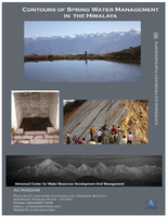 Contours of Spring Water Management in the Himalaya
 The document "Contours of Spring Water Management in the Himalaya" by ACWADAM highlights the critical role of spring water in sustaining the rural populations of the Indian Himalaya, where approximately 60% of people rely on natural springs for drinking and irrigation. The Himalayan region, characterized by diverse geological structures, poses significant challenges to groundwater management due to its complex hydrogeology, which affects aquifer continuity and spring discharge. As many springs are drying up or becoming seasonal due to climate change and human activities, there is an urgent need for effective water management practices that involve community participation and a thorough understanding of the geological context.
ACWADAM has been actively engaged in research and action programs focusing on hydrogeological studies and spring water conservation in partnership with various organizations. Their efforts include detailed investigations to characterize spring recharge areas, monitor water quality, and implement community-based spring management systems. Through collaborations with organizations like CHIRAG and Himmotthan, ACWADAM aims to integrate scientific knowledge into local practices, ensuring that interventions are informed by geological realities and hydrological principles. This approach is essential for developing sustainable water management strategies that address both the immediate needs of local communities and the long-term viability of spring resources.
In conclusion, the document emphasizes the need for a paradigm shift in how spring water resources are managed in the Himalaya. By focusing on hydrogeological education and community engagement, ACWADAM aims to enhance the resilience of these vital water sources in the face of changing climatic conditions and increasing demand. Future research initiatives are necessary to deepen the understanding of groundwater dynamics and inform policies that promote sustainable practices. This holistic approach is crucial for securing water availability for rural populations reliant on these springs, thus ensuring their livelihoods and well-being.
-
 Case Study of Garhwal Springs
 The document focuses on the geohydrology of springwater management in the Garhwal Himalaya region of Uttarakhand, highlighting the challenges faced by local communities in accessing reliable water sources. Despite being the origin of major rivers, residents in the Himalayas often experience water shortages, primarily relying on springs for their drinking and domestic needs. The Himmotthan Initiative, in partnership with ACWADAM, aims to improve catchment area planning for spring water management through geohydrological studies, training programs, and community engagement.
Key aspects of the initiative include detailed hydrogeological investigations of selected springs, which encompass assessing spring discharge, water quality, and appropriate recharge measures. The study identifies four springs in the region, analyzing their geological settings and discharge patterns. Recommendations for enhancing spring discharge, protecting aquifers, and training local stakeholders in water data collection are integral parts of the initiative. The document emphasizes the necessity for a collaborative approach to address the social and administrative challenges encountered in implementing effective spring management practices.
In conclusion, the pilot studies underscore the significance of hydrogeological assessments in spring development and management, showcasing how targeted treatment measures can lead to improved water availability. Continuous capacity building and community involvement are essential for sustaining spring recharge initiatives, as they empower local organizations to monitor and manage water resources effectively. The insights gained from this study not only contribute to the understanding of spring hydrology but also highlight the importance of integrating scientific knowledge with community needs for effective water resource management in the Himalayas.
-
 PROCESS OF MAPPING
 The Advanced Center for Water Resources Development and Management uses hydrogeology to map springs, which are influenced by the rock cycle and inclined rock. The process involves using GPS, hammers, and clinometers to identify fracture zones, stream channels, and road cuttings. A springshed is an area bounded by a ridge and drains through a common point. Natural recharge occurs in springsheds, which can include one or more watersheds and aquifers.
-
 Understanding the Impacts from Springshed Development across the Himalayan Region
 The People's Science Institute in Dehradun has been working on regenerating underground seepage in the Himalayan region through engineering, vegetation, and social measures. These measures include trenching, small check dams/gullyplugs, recharge pits, planting of fuelwood, fodder, fruit trees, and grass, and social fencing. Secondary information collection steps for springshed development include hydrological surveys, socio-economic surveys, geo-tagged spring's inventory, spring discharge, water quality, household and population, and institutions. The finalization of critical springs, community mobilization, preparation of spring sheds, development plans, awareness building, formation of Water User Groups (WUGs), selection and capacity building, exposure visits, agreement with the community, establishment of data collection and monitoring systems, water balance, recharge area demarcation, aquifer mapping, treatment measures, water and sanitation protocols, budget, implementation of plans with community participation, evaluation, discharge, quality, survival rate, water sharing, livelihoods, operation and maintenance, and survey benefits. The springshed development activities have led to increased water storage capacity, soil retention, and improved domestic water availability and farm productivity.
-
 GROUNDWATER, AQUIFERS, SPRINGS AN INTRODUCTION
 ACWADAM is a think-tank and action-research organization focused on the science of groundwater and its applications to societal development. They work on aquifer-based, participatory groundwater management, training, action research, and policy and programs. The organization has trained over a thousand individuals and has influenced key decisions on aquifer-based participatory groundwater management in many locales. They have also developed a nuanced approach to aquifer-based and community-centric groundwater management, which has been incorporated into mainstream programs. ACWADAM has evolved as a leading think tank on hydrogeology and groundwater management in India. Groundwater usage has evolved from ancient times, with access from shallow sources, such as wells, springs, and qanats, to the present day. The hydrological cycle has changed, with changes in the hydrological cycle affecting different sectors, such as India's mountain groundwater springs. The organization has also contributed to the development of the 'aquifer mapping' programme under the 12th Plan and has influenced decisions on groundwater under various programs like IWMP and MGNREGS.
-
 Research Questions Adaptive experiments
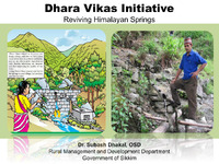
 The research focuses on the revival of Himalayan springs in Sikkim, aiming to improve water supply and agriculture. The initiative, DharaVikas, has been successful in implementing adaptive experiments and learning from mistakes. The project has involved a range of activities, including preparing a spring atlas, assessing the vulnerability of gram panchayats, initiating pilots, and developing local capacity. The focus is on aquifers, with 120 ha of land taken up at recharge areas in 2013-14. The initiative has also focused on identifying vulnerable villages and critical springs. The project has faced challenges, such as learning from mistakes and implementing implementation guidelines. The research questions include the feasibility of reviving Himalayan springs, the need for recharge areas, the amount of investment needed, the expected benefits to farmers, and the impact of the initiative on the environment. The initiative aims to address the pressing needs of the village and ensure sustainable water supply.
-
 Spring Hydrogeology_ Training Manual
 Springs are a vital source of water supply to villages in the Himalaya, with about 60% of the population relying on natural spring water for drinking water, sanitation, and irrigation. With changing climatic conditions and rainfall patterns, many villages, hamlets, and settlements are facing potential drinking water shortages. Hydrogeological investigations are crucial to address this crisis and the impending peril. The revival of springs is essential for the region's sustainable growth. Over the last few years, many governmental and non-governmental organizations have initiated spring development programs in the Himalayan states. However, many of these programs fail due to lack of knowledge of the subsurface and lack of hydrogeological input in planning recharge measures. Springs are controlled by diverse geological features, which are not targeted by conventional watershed development projects. Recharge plans for springs must address quality issues, which cannot be done without understanding the geological influence on the water. The recharge area of a spring is decided after considering factors such as geology, permeability, weather, spring discharge measurement, and water quality monitoring.
-
 Importance of ground water in The Nilgiri district
 Groundwater is a vital resource that feeds various sources, including aquifers and springs. Aquifers are rocks or rock material that allow groundwater to store and move within it, making it available to wells, springs, and bore wells. Springs are locations or points on the ground surface where water from beneath the ground emerges on to the surface. Spring depletion can be caused by factors such as climate, land-cover, land-use, and seismicity. Understanding hydrogeology is the first step towards spring management, as it helps identify recharge areas and determine the discharge patterns in these rocks. Spring hydrographs are used to measure precipitation, reduced water levels, and cumulative rainfall. Water quality is also a crucial aspect of groundwater management. Socio-hydrogeology and springshed management are essential for maintaining water quality and preventing groundwater depletion. The Advanced Center for Water Resources Development And Management (ACWADAM) provides information on groundwater sanitation, socio-hydrogeology, and springshed management.
-
 PERMISSIBLE LIMITS OF WATER POLLUTANTS
 This presentation contains the permissible of water pollutant.
-
 FICCI - Geospatial Technologies in India - Success Stories
 Geospatial technologies in India have been instrumental in various sectors, including agriculture, mining, infrastructure, transportation, logistics, homeland security, disaster management, defense, and urban planning. These technologies are considered powerful tools that can effectively serve the overall developmental needs of the modern world. As India strives to achieve its developmental goals, the multifaceted and specialized capabilities offered by geospatial technologies will play a crucial role for information management in the future.
Maintaining geospatial technologies for effective decision-making and better governance is one of the mandates of FICCI. This publication is a compilation of Indian case studies of successful applications of this technology, showcasing their immense potential as a tool for planning and management of resources by diverse stakeholders. The publication aims to help in propagating the adoption of this promising technology by various stakeholders from the public and private sector.
The publication also highlights the importance of mapping technologies in preserving access to natural resources and biodiversity, as well as the role of UAVs in social research and the use of LiDAR technology for smart city surveillance.
-
 The rain–runoff response of tropical humid forest ecosystems to use and reforestation in the Western Ghats of India_ Journal of Hydrology
 The study investigates the impact of forest degradation and tree-plantation on degraded or modified forest ecosystems in the Western Ghats of India.
-
 Nevada Springs Restoration Guide
 Nevada Springs Restoration Workbook is a comprehensive guide for improving the sustainability of Nevada's springs, which are crucial ecosystems that provide water for ranches, farms, and support unique plants and animals. The book outlines suggestions for improving spring care and is intended for public and government springs stewards throughout the state. The approach and methods proposed apply directly to Nevada springs but may also be useful for springs stewardship in most arid states and regions. The Nevada Springs Conservation Plan summarizes the current conditions, threats, and actions needed to conserve Nevada's springs. The handbook suggests a rationale, methods, and approaches for achieving desired conditions and goals for springs management, recognizing the primacy of stewardship rights and goals. The approach can be used to address issues such as defining desired conditions, identifying the problem, determining its severity, solving it, and maintaining the desired condition. If broadly adopted, this approach will greatly improve the ecological health and integrity of these highly valued resources and our natural heritage in general.
-
 Nilgiris District Disaster Management Plan
 The District Disaster Management Plan 2014-2015 outlines the socio-economic profile, geographical location, area and population, climate and rainfall, irrigation, and past disasters in the Nilgiris District. The plan includes a multihazard disaster management plan, a Hazard, Vulnerability, Capacity and Risk Assessment (HVCRA), and a comprehensive plan for prevention and mitigation measures. The plan includes the roles and actions of various departments, such as the Revenue Department, Police Department, Fire and Rescue Services Department, Rural Development Department, Public Works Department, Highways Department, Civil Supplies Department, Agriculture Department, Medical and Public Health Department, Animal Husbandry Department, Transport Department, Education Department, NCC, NRC & Home Guards, and Defence Personnel. The plan also includes a list of safe shelters, inventory and stock, fire stations, voluntary organizations, medical teams, community kitchens, bakeries, relief and rescue materials, and other essential resources. The plan also includes a list of emergency services, such as emergency medical teams, fire stations, and emergency services, and a list of community halls and bakeries. The plan also includes a list of relief and rescue materials available.
-
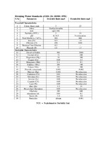 WaterQualityStandards
 The Drinking Water Standards of BIS (IS: 10500: 1991) outline the essential characteristics of drinking water, including color, odor, taste, turbidity, pH, total hardness, iron, chloride, residual free chlorine, fluoride, and pesticides. The water's electrical conductivity is also a crucial factor. The upper permissible safe limit for electrical conductivity in water is μmhos/cm at 25 ̊C. The water's quality is evaluated based on Sodium (Na) % Electrical Conductivity μmhos/cm at 25 ̊C. The water's boron concentration is rated based on the class of water, with a rating of excellent <0.25 < 250 < 10 < 1.25, good 20-40 250-750 10-18 1.25-2.0, medium 40-60 750-2250 18-26 2.0-2.5, bad 60-80 2250-4000 >26 2.5-3.0, and very bad >80 >4000 >26 >3.0. The trace elements tolerance for irrigation waters is also outlined. The maximum tolerance limits for industrial effluents discharged (mg/l) are set for color and odor, suspended solids, pH value, dissolved solids, and temperature ̊C. Pesticides are not allowed in the water.
-
 Significance of Geomorphic Analysis of Watershed for Optimization of Recharge Structures
 he book "Significance of Geomorphic Analysis of Watershed for the Optimization of Recharge Structures" by Dr. D.K. Chadha and Dr. B.R. Neupane, published by UNESCO, aims to integrate geomorphic analysis and stream ordering into the rainwater harvesting initiative. The book presents techniques for optimum utilization of available runoff at different locations within the watershed based on stream ordering and geomorphic analysis of the drainage area. The book is aimed at prompting policy review and research, as well as developing future strategies for implementing measures for water harvesting programs. The book will be useful as a reference manual and guidebook for program managers, students, and field workers working on soil and water conservation or water resources development projects. The continuous increasing demand for water resources, particularly for irrigation, has reached to the point where groundwater development is becoming a major concern.
-
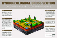 HYDROGEOLOGICAL CROSS SECTION O F U P P E R P L AT E A U O F T H E N I L G I R I S
 Wetlands are land areas saturated with water, characterized by aquatic plants adapted to the unique hydric soil. They play various roles in the environment, such as water purification, flood control, carbon sinking, and shoreline stability. Wetlands are the most biologically diverse ecosystems, home to a wide range of plant and animal life. The main types of wetland types include swamps, marshes, bogs, and fens. Springs are locations where water from beneath the ground emerges onto the surface, while streams are bodies of water with surface water flowing within the bed and banks of a channel. Laterite is a soil and rock type rich in iron and aluminum, commonly found in hot and wet tropical areas. Charnockites are metamorphic rocks formed by high-grade regional metamorphic processes, often foliated with alternating darker and lighter colored bands called "gneissic banding."