-
 Menstrual Hygiene Management Day 2019
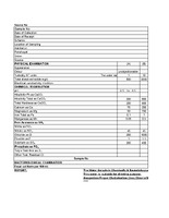
 The document discusses the significance of Menstrual Hygiene Management Day, celebrated on May 28, to raise awareness about the challenges women and girls face due to menstruation, which is often surrounded by stigma and misinformation. It highlights an exclusive health camp organized for women and adolescent girls in slums, where medical professionals provided consultations on menstrual hygiene and reproductive health, addressing common concerns such as irregular periods and the importance of a balanced diet. The document also emphasizes the negative impact of societal taboos on women's health and education, noting that many girls drop out of school when they begin menstruating due to inadequate sanitation facilities. Additionally, it touches on the environmental issues related to the disposal of sanitary products and the need for open discussions to empower women and girls regarding their menstrual health.
-
 Health camp _karamadai _Press Note
 The document discusses a health camp organized for sanitation workers in Karamadai Town Panchayat, highlighting the health risks these workers face due to their exposure to unhygienic conditions and harmful gases while managing waste. It emphasizes the need for regular healthcare and monitoring to improve public health among this vulnerable group. The Tamil Nadu Urban Sanitation Support Programme (TNUSSP) has partnered with local hospitals to provide free medical camps, offering essential health services such as blood pressure and sugar level checks, which have benefited over 200 workers and their families. The success of these camps has encouraged other nearby towns to initiate similar health initiatives, reflecting a growing recognition of the importance of healthcare for sanitation workers.
-
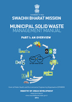 Municipal Solid Waste Management Manuel_Part I,II,III
 The manuel outlines the challenges and strategies for managing municipal solid waste (MSW) in urban India, emphasizing the need for effective waste management systems due to the increasing urban population and waste generation. It discusses various funding sources for waste management, including government grants, public-private partnerships, and loans from development agencies, while highlighting the importance of stakeholder involvement and community participation in planning and implementation. The manual presents a structured approach to developing a municipal solid waste management plan, which includes assessing current situations, identifying gaps, and establishing clear action plans for waste collection, treatment, and disposal. It also emphasizes the significance of recycling, composting, and energy recovery from waste, alongside the integration of informal waste management sectors to enhance resource recovery and reduce environmental impacts. Overall, the document serves as a comprehensive guide for urban local bodies to improve their waste management practices and ensure sustainable urban development.
-
 Solid Waste Management_Supreme Court Report_March_99
 The document outlines comprehensive recommendations for improving solid waste management in urban areas, emphasizing the need for organized waste collection, segregation, and processing. It suggests implementing door-to-door collection systems, utilizing NGOs and private sector participation to enhance efficiency, and establishing designated disposal sites for hazardous waste. The report also highlights the importance of community involvement, proper training for waste management personnel, and the adoption of environmentally friendly practices like vermi-composting. Furthermore, it calls for local bodies to adopt simple technologies and set achievable standards to gradually improve waste management services over time, ensuring that municipalities can meet the needs of their communities effectively.
-
 Final Guidelines on Buffer Zone
 This document, published by the Central Pollution Control Board in April 2017, outlines the necessary provisions for establishing buffer zones around solid waste processing and disposal facilities in India. It emphasizes the importance of maintaining a no-development zone to minimize environmental and public health risks associated with waste management operations. The guidelines define key terms such as buffer zone, separation distance, and green belt, and recommend specific distances and land use practices to ensure effective waste management while addressing community concerns. Additionally, the document highlights the regulatory framework guiding these practices and the need for local authorities to collaborate with pollution control boards to implement these guidelines effectively, ultimately aiming to enhance the aesthetic appeal and operational safety of waste management facilities.
-
 Tamil Nadu Urban Sanitation Support Program_SKCAS_VM
 The document discusses the critical importance of sanitation, which encompasses the safe management of human waste and solid waste, including hazardous materials. It highlights the severe health implications of inadequate sanitation, noting that poor sanitation contributes to diseases such as cholera and diarrhea, and is linked to malnutrition, with millions lacking basic sanitation facilities. The document outlines the components of a full cycle sanitation system, emphasizing the need for safe toilet usage, effective waste treatment, and the prevention of groundwater contamination. It also references legislative measures aimed at improving sanitation practices and reducing manual scavenging, underscoring the collaborative efforts of organizations like the Bill and Melinda Gates Foundation and the Tamil Nadu government in addressing these challenges.
-
 Tamil Nadu Urban Sanitation Support Program
 This presentation focuses on the Tamil Nadu Urban Sanitation Support Program, outlining the sanitation value chain, which includes user interfaces, containment, collection, treatment, and disposal of waste. It discusses the importance of safe toilet usage, the prohibition of manual scavenging, and various treatment systems, highlighting a proposed Faecal Sludge Treatment Plant (FSTP) model designed to handle up to 22,000 liters of fecal sludge daily, benefiting a population of 50,000. The presentation emphasizes the need for safe practices in waste disposal and reuse, aiming to prevent illegal dumping and promote the generation of treated wastewater and composted sludge.
-
 Water Sample results_Coonoor_April_2014
 Coonoor area water sample result details.
-
 Human Wildlife Conflict_ Questionnaire
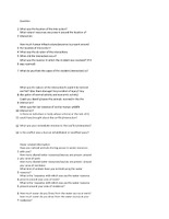
 In this document provides you the questions related human wildlife conflict .
-
 Water sample_Test report
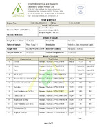
 The provided documents consist of multiple test reports detailing the analysis of water samples collected by Keystone Foundation. Each report includes information about the sample's characteristics, such as color, odor, taste, pH level, electrical conductivity, total dissolved solids, turbidity, hardness, and various chemical constituents like calcium, magnesium, chlorides, and nitrates. The results indicate that the samples generally meet acceptable standards for drinking water, with specific measurements provided for each characteristic compared against established limits.
-
 household survey format_V1
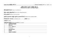
 The document outlines a structured survey format for the Springs Project, developed by the Keystone Foundation, aimed at assessing various aspects of household water usage, sanitation, and health in Tamil-speaking communities. It includes sections for gathering information on water quality, sources, availability, and sanitation practices, as well as the impact of waterborne diseases on the population. The survey seeks to collect data on household demographics, landholding sizes, primary occupations, and methods of waste disposal, thereby providing a comprehensive understanding of the community's water-related challenges and needs.
-
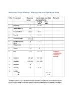 Water_Quality_Anbu Anna Colony_22_March_2018
 The document presents an assessment of water quality in the Anbu Anna Colony Wetland, highlighting various parameters measured on that date. It indicates that the water quality is generally good, with most parameters meeting the permissible limits for drinking and river water, except for elevated iron levels, which is a common issue in wetlands in the Nilgiris region. Key measurements include a pH of 7, a temperature of 16°C, and the absence of faecal coliform, while fluoride, dissolved oxygen, and turbidity levels also fall within acceptable ranges. Overall, the findings suggest that while the water quality is satisfactory, attention is needed regarding iron contamination.
-
 Ripples in Water - Reflections from Keystone's Work on Water in the Nilgiri Biosphere Reserve : 1995 - 2019
 This book details Keystone's work on Hill Waters and associated water bodies such as springs, streams, wetlands, etc. Nilgiris itself is a very important catchment area and this book walks us through the major initiatives in Water, undertaken by Keystone, and the learnings and commuity responses from it.
-
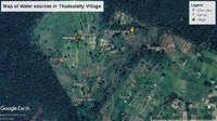 water resource map of Thadasalhatty
 It is a map of water bodies found in Thadasalhatty village.They are natural springs located inside village and bordering Forest.The reason to make the water inventory and map was to see how water conservation works can be taken up under conservation agreements.
-
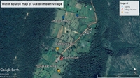 water resource map of Galidhimbam
 It is a map of water bodies found in the Galidhimbam Village.They are natural springs locate inside village and bordering forest. The reason to make the water inventory and map was to see how water conservation works can be taken up under conservation agreements.After the map was created, in Galidhimbam from Governement in total 8 water bodies were supported like wells and checkdams, which are not captured in the map.
-
 Water resource map of Mavanatham
 It is a map of water bodies found in the Mavanatham Village. They are natural springs locate inside village and bordering forest. The reason to make the water inventory and map was to see how water conservation works can be taken up under conservation agreements.
-
 Water resource map of Itterai
 It is a map of water bodies found in the Itterai Village. They are natural springs and few are located near to naeri trees specifically.There is checkdam also mentioned in the map which were built long back. The reason to make the water inventory and map was to see how water conservation works can be taken up under conservation agreements.
-
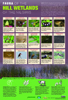 Poster on fauna of wetlands
-
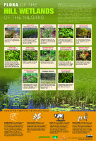 Poster on flora of wetlands
-
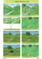 Poster on Happy Valley Springshed Restoration_English, Tamil
-
 Posters on Hydrogeology of the region (3 nos)
-
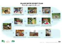 Poster on Water Security Plan - Bilingual
-
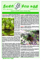 Special edition of Seemai Sudhi Tribal Newspaper on springs
-
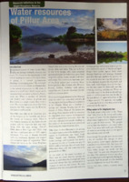 Article in the NNHS newsletter on water resources of the Pillur Area
-
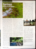 Article in the NNHS newsletter on Springs