-
 Everyday Ethnicity-book review
 The article reviews Daniel Bass's book on Up-country Tamil identity politics in Sri Lanka, emphasizing the historical context of ethnic identity amidst the country's violent ethnic conflicts. It discusses how Up-country Tamils, primarily descendants of Indian plantation workers, have sought to assert their identity in a multi-ethnic Sri Lanka rather than pursuing separatism. By fostering ethnic solidarity and cultural practices, they have improved their social and political conditions. The book highlights the impact of state and structural violence on this community and explores their ongoing struggles for recognition and belonging in a post-war society, making it a critical resource for studies on diaspora and ethnicity.
-
 The Educational Progress of the Indian Tamil minority
 The chapter examines the educational progress of the Indian Tamil minority in Sri Lanka's plantations, highlighting the historical struggles they faced regarding citizenship and access to education. Initially brought by the British as low-caste laborers, the Indian Tamils' educational advancements stemmed from complex interactions of caste, ethnicity, and economics over time. The chapter identifies five key phases of educational development, demonstrating that while various political and economic factors have historically hindered progress, recent state interventions and community demands have led to significant improvements in literacy and school enrollment, especially among women.
-
 Detention of Activist
 The Economic and Political Weekly discusses the detention of R. R. Sivalingam, a human rights activist and Sri Lankan citizen of Indian origin, who has been held indefinitely under the Foreigners Act in Tamil Nadu since August 1993. His detention is seen as a retaliation for his advocacy for the rights of repatriated Tamils and other marginalized groups. Despite his longstanding residence in India and contributions to human rights, his citizenship application has been stalled, raising concerns about his health and well-being in solitary confinement. The authors urge readers to protest against his detention and demand his release.
-
 Crimes in the name of Diplomacy
 The collaboration between Economic and Political Weekly and JSTOR aims to digitize and preserve access to research materials. A critical examination by Stan Lourdusamy highlights how the Indian government exploited Sri Lankan Tamils for geopolitical gain, only to abandon them post-Rajiv Gandhi's assassination. The article discusses the historical mistreatment of Tamils in Sri Lanka and their forced repatriation to India, where they faced further exploitation and discrimination. It emphasizes the responsibility of the Indian government to address human rights violations committed during military interventions and to ensure justice for the Tamil community in both India and Sri Lanka.
-
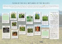 FLORA OF THE HILL WETLANDS OF THE NILGIRIS
 The Nilgiris wetlands are critical ecosystems supporting diverse flora and fauna while providing essential services like water purification and biodiversity support. However, these habitats face significant threats, including invasive species, pesticide pollution from nearby agriculture, overgrazing by cattle, and land-use changes such as conversion to agricultural and urban areas. This degradation has led to the loss of biodiversity and put many species at risk of extinction. There is a pressing need for greater awareness and understanding of the wetlands' importance to prevent further destruction and preserve their ecological functions.
-
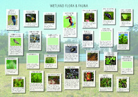 WETLAND FLORA & FAUNA JUNCUS GLAUCUS
 Wetland ecosystems host a diverse array of flora and fauna, including various species of rushes, sedges, and herbs that thrive in marshy areas, swamps, and riverbanks. Key plant species like Common Rush (Juncus glaucus) and Watercress (Rorippa indica) play vital roles in these habitats, offering food and medicinal value. Numerous animals, such as the Grey Wagtail and Indian Pond Heron, inhabit these wetlands, feeding on insects and small creatures. Insects like the Danaid Eggfly also frequent these areas, contributing to the ecological balance. Overall, wetlands are crucial for biodiversity and provide essential resources for both wildlife and humans.
-
 A Toolkit for Integrated Wetland Assessment
 The document outlines a toolkit for integrated wetland assessment created by experts from the World Conservation Union. It emphasizes the ecological and economic significance of wetlands, which provide vital resources and services for local communities, especially poorer groups. As wetlands face increasing threats from human activities, the toolkit aims to improve decision-making by integrating biodiversity, economic valuation, and livelihood assessments. It provides methodologies for assessing wetland health and resource use, highlighting the need for collaboration among conservationists, policymakers, and local communities to ensure sustainable management and protection of these critical ecosystems.
-
 Urban Policy Dialogues_ Sustainable Development Goals
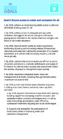
 The goals outlined emphasize achieving universal access to safe drinking water, sanitation, and affordable energy by 2030, while promoting sustainable practices and technology. Key objectives include improving water quality, enhancing energy efficiency, and increasing renewable energy use. Urban development aims to provide safe housing, accessible transport, and resilient infrastructure, particularly for vulnerable groups. Additionally, there is a strong focus on combating climate change through integrated national policies, education, and enhancing resilience to climate-related disasters, alongside support for developing countries in their climate initiatives.
-
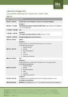 Urban Policy Dialogues_ Sustainable Development Goals and Urban India Agenda
 The Urban Policy Dialogues held on November 10-11, 2016, focused on integrating the Sustainable Development Goals (SDGs) within urban policies in India, addressing both opportunities and challenges. The agenda included presentations and discussions on critical areas such as climate change, energy, housing, and water sanitation, emphasizing implementation frameworks and monitoring processes. Participants engaged in group sessions to develop actionable insights, culminating in thematic discussions on synergies between environments and the rural-urban continuum. The event concluded with reflections on achieving SDGs and strategies for sustaining urban development progress in India.
-
 Heavy rain triggers landslips in Ooty, Coonoor
 Heavy rainfall in the Nilgiri hills, particularly in Coonoor, caused significant disruptions, including landslips and road closures. A bridge under construction near Marapalam was partially washed away, leading to a temporary blockage of the Coonoor-Mettupalayam road for over six hours, during which traffic was redirected. Coonoor recorded the highest rainfall in the district at 90.5 mm, resulting in several minor landslips and delays for the Nilgiri Mountain Railway. Despite clearing efforts by local authorities, further rain could necessitate additional road closures. Schools in Coonoor were closed as a precautionary measure.
-
 Landslip in Nilgiris district
 Heavy rains in the Nilgiris district have caused significant disruptions, including landslips that blocked the Mettupalayam-Coonoor road and delayed the Nilgiris Mountain Rail service. A temporary bridge was washed away, completely halting traffic between Mettupalayam and Coonoor, with diversions implemented via Kotagiri. Additionally, a tree fell on a house in Ulikkal, but fortunately, no injuries were reported. While some road traffic resumed later, repairs remain temporary as more rain is expected in the area, affecting local infrastructure and safety.
-
 HOW HILLS OF SOUTH INDIA DIFFER FROM NORTHERN HILLS
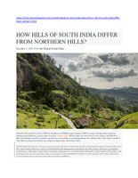
 The hills of South India, including Ooty, Kodaikanal, and Coonoor, differ significantly from the northern hills in terms of climate and weather patterns. While northern regions experience winter snow due to Western Disturbances, southern hills only see temperature drops and frost, with no snowfall. The Northeast Monsoon brings considerable rainfall during winter, but temperatures can still fall below 5°C at night. Days remain mild, around 16°C, with mostly sunny weather. Unlike the northern hills, southern regions avoid severe winter weather disruptions, making them more stable and accessible during the season.
-
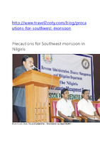 Precautions for South West Monsoon_ District Collector
 As the southwest monsoon begins in the Nilgiris district, the district collector, Mr. Shankar, has established control rooms in six taluks to assist the public during emergencies. A meeting at the Tribal cultural center highlighted precautionary measures, with 466 schools and community centers prepared to shelter those affected by disasters. Various departments, including police and fire services, have designated officials to manage relief efforts. The control rooms will operate 24/7 until December, and the public can reach out for immediate assistance during floods, landslides, or other emergencies using provided contact numbers.
-
 NATIONAL DISASTER MANAGEMENT GUIDELINES MANAGEMENT OF LANDSLIDES AND SNOW AVALANCHES
 The National Disaster Management Guidelines for managing landslides and snow avalanches aim to minimize the impact of these hazards on life, property, and economic activities across India. Formulated by the National Disaster Management Authority (NDMA), these guidelines emphasize a proactive approach to disaster management, focusing on hazard recognition, risk assessment, and mitigation strategies through stakeholder engagement. Key components include landslide hazard zonation mapping, geological and geotechnical investigations, capacity building, public awareness, and the establishment of early warning systems. The guidelines also call for regulatory measures, compliance reviews, and the integration of landslide management into national and state disaster plans to enhance community resilience and safety.
-
 Report of Social Dynamics Scoping
 The report on landslide risk assessment in South Asia highlights significant factors contributing to landslides in the Nilgiris region, primarily linked to development activities such as resort construction on unstable land. Poor infrastructure and inadequate drainage also exacerbate the issue, especially during monsoons. Local populations, particularly landless Tamils and tribal groups, face varying vulnerability levels, with the latter generally being less affected. Coordination among multiple institutions involved in landslide management is poor, complicating disaster response efforts. An early warning system, operated by a local NGO, exists but lacks effective dissemination and validation. Overall, increased urban development threatens land stability and enhances landslide risks.
-
 A Study of Current Socio-Economic Conditions of the Tribal Communities in Nilgiris District, Tamilnadu
 The study examines the socio-economic conditions of tribal communities in the Nilgiris District of Tamil Nadu, highlighting the significant disparities between these communities and the mainstream population. With approximately 200,000 tribal inhabitants, the research, based on data from 100 households, reveals lower per capita income, GDP, and health status among the tribes, alongside higher illiteracy rates. The survey indicates that women in these communities exhibit slightly higher literacy rates than men. Despite some government efforts to improve welfare, poverty remains prevalent, necessitating further targeted interventions for equitable growth and development in these tribal populations.
-
 The National Family Health Survey
 The National Family Health Survey (NFHS-4) conducted in 2015-16 provides critical data on population, health, and nutrition across India, including district-level insights for The Nilgiris in Tamil Nadu. This round introduced new topics such as malaria prevention and expanded health measurements like blood pressure and glucose levels. It assessed various indicators through detailed household and individual questionnaires, revealing key trends in education, health care access, and family planning. Notably, the survey highlighted issues such as literacy rates, maternal health, child immunization, and nutritional status, which are essential for shaping health policies and programs in the region.
-
 The District Level Household and Facility Survey
 The District Level Household and Facility Survey (DLHS-4) conducted in Nilgiris during 2012-2013 aimed to assess reproductive and child health indicators at a district level in India, following previous rounds in 1998, 2002, and 2007. The survey gathered data from 1,297 households and 1,010 ever-married women, focusing on socio-economic characteristics, maternal health, and immunization. Key findings indicated improvements in literacy rates, healthcare access, and family planning methods, while challenges remained in areas such as antenatal care and treatment for childhood diseases. The information is crucial for monitoring health programs and guiding policy decisions.
-
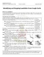 Identifying and Mapping Landslides
 The tutorial from the Geological Survey of India focuses on identifying and mapping landslides using Google Earth. Landslides, defined as the movement of rock or debris down a slope, can be classified by material type (rock, earth, debris) and movement type (fall, topple, slide, flow). The tutorial emphasizes the importance of accurately mapping landslides, including their dimensions and features, using high-resolution satellite images and historical data. It describes practical steps for measuring landslides and exporting the data for analysis in GIS software, facilitating effective landslide susceptibility mapping to understand their triggers and impacts.
-
 NOTE ON POST DIASTER LAND SLIDE STUDIES_Malappuram,Palakad
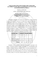
 In June 2018, heavy rainfall in the Malappuram and Palakkad districts of Kerala triggered multiple landslides, leading a Geological Survey of India team to assess 13 events, including debris flows and slides. The primary causes identified include slope excavation, river erosion, poor drainage maintenance, and natural geological factors. Each landslide was documented with specific attributes, revealing that many were exacerbated by prior land modifications for agriculture, which blocked natural drainage. The study recommends immediate and long-term remedial measures such as maintaining drainage systems and removing obstructive debris to prevent future incidents.
-
 NOTE ON POST DISASTER STUDIES FOR LANDSLIDES_Wayanad
 In June 2018, heavy rainfall triggered multiple landslides in northern Kerala, particularly affecting the Kozhikode, Wayanad, and Kannur districts. The Geological Survey of India conducted a rapid assessment, documenting 36 landslide incidents, with Kozhikode being the most impacted, resulting in 14 fatalities and significant property damage. The landslides were primarily caused by saturated soil conditions, increased pore water pressure, and unscientific slope modifications. Key recommendations included removing precarious boulders, restoring natural drainage, and conducting detailed geological studies before further construction. The report highlights the urgent need for improved land management practices to mitigate future risks.
-
 Detailed geo parametric attributes of a landslide
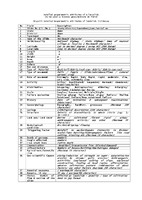
 The document outlines a comprehensive framework for recording detailed geoparametric attributes of landslides, intended for use by geoscientists in the field. It includes 42 specific data points such as the slide's identification number, geographical location (latitude and longitude), physical dimensions (length, width, height, area, volume), type and movement of material, activity status, geomorphological and geological context, triggering factors, and the impact on human life and infrastructure. Additionally, it emphasizes the need for remedial measures and allows for the inclusion of photographic evidence and a summary of findings, categorizing landslides into three distinct types.
-
 Report a landslide
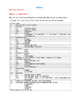
 The document provides detailed information on landslides, including reporting, classification, and components involved.
-
 LANDSLIDE HAZARD ZONATION
 Landslide hazard zonation (LHZ) maps are essential for identifying areas at risk of landslides, which can lead to significant casualties and economic losses, particularly as urbanization and climate change increase vulnerability. Effective LHZ involves categorizing land based on factors contributing to slope instability, including geology, topography, soil type, and land use. Various methodologies, both qualitative and quantitative, are employed to assess and predict landslide risks. Geographic Information Systems (GIS) and remote sensing enhance data collection and analysis, improving hazard mapping accuracy. Recognizing and mitigating these hazards is crucial for informed urban planning and disaster management.
-
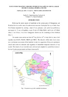
 RAINFALL VS LANDSLIDE STUDY IN NILGIRI DISTRICT, TAMILNADU, SOUTH INDIA
 The study investigates the relationship between rainfall and landslides in the Nilgiri district of Tamil Nadu, India, over a decade from 2003 to 2012. It identifies a significant correlation, indicating that heavy rainfall, particularly during the Northeast Monsoon, is a primary trigger for landslides, notably in the Coonoor and Wellington regions. Using GIS to analyze rainfall data and landslide occurrences, the research establishes that areas with higher rainfall experience more landslides, while moderate rainfall areas also face risks. The findings highlight the necessity for effective land management and disaster preparedness in this hilly terrain.
