-
 Landslide Hazard Mitigation in the Nilgiris District, India– Environmental and Societal Issues
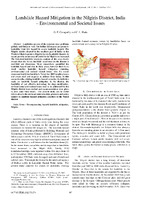
 Landslides pose a significant risk in the Nilgiris district of India, which is categorized as highly prone to such hazards, especially during the rainy season. The frequency of landslides has increased, with a devastating event in November 2009 resulting in numerous casualties and extensive property damage. Despite existing research on landslide hazards, there is a lack of effective mitigation strategies and public awareness. This study emphasizes the need for comprehensive landslide management, including the use of cost-effective soil bioengineering techniques for slope stabilization. It advocates for improved planning, community education, and restrictions on development in high-risk areas to enhance safety and resilience.
-
 District Statistical Hand Book
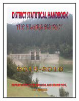
 The "District Statistical Handbook" for The Nilgiris District (2015-16) presents comprehensive data on various sectors, including demographics, geography, economy, and public services, aimed at aiding planners and researchers. The district, known for its picturesque landscapes, has a population of 735,394, with significant contributions from agriculture, mainly tea and coffee production. The tourism sector thrives due to attractions like the Botanical Garden and Doddabetta Peak. The report highlights the region's development in infrastructure, healthcare, education, and social welfare initiatives, while also acknowledging the contributions of various government and private organizations in these areas.
-
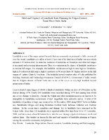
 Need and Urgency of Landslide Risk Planning for Nilgiri District,Tamil Nadu State, India
 The paper emphasizes the urgent need for effective landslide risk planning in the Nilgiri District of Tamil Nadu, India, which is highly prone to landslides due to its geographical features and heavy rainfall. Historical data indicates significant landslide incidents, particularly during extreme weather, leading to loss of life and property. It advocates for a comprehensive risk assessment framework that includes hazard recognition and the development of hazard maps to mitigate risks. The authors stress the importance of integrating scientific understanding with community engagement in planning processes to enhance safety and reduce vulnerability in landslide-affected areas.
-
 A STUDY ON FACTORS INFLUENCING LANDSLIDES IN NILGIRIS, TAMILNADU, INDIA
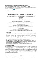
 The study explores the factors contributing to landslides in the Nilgiris district of Tamil Nadu, India, a region prone to such natural hazards due to heavy rainfall from monsoons and its steep topography. It identifies both natural causes, like high rainfall intensity and soil characteristics, and human-induced factors, such as deforestation and urban development, as significant contributors to landslides. The research aims to develop effective mitigation strategies by analyzing watershed characteristics, particularly in the Kattery watershed, which exemplifies the area's complex interplay of factors influencing landslide occurrences.
-
 Environmental aspects of landslides in Nilgiris district, India: Issues and Needs
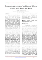
 The Nilgiris district in Tamil Nadu, India, faces significant landslide hazards, exacerbated by urbanization, deforestation, and inadequate drainage systems. The study identifies the region as highly susceptible to landslides, stressing the need for effective hazard mitigation strategies. Recommendations include raising public awareness, improving land-use management, and implementing bioengineering solutions for slope stabilization. The increasing frequency and severity of landslides necessitate urgent action from policymakers and community leaders to enhance safety measures and educate residents about risks. Overall, a comprehensive approach is essential to address both environmental and societal impacts of landslides in this vulnerable area.
-
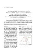 Demarcation of landslide vulnerable zones in and around Achanakal, South India using remote sensing and GIS techniques
 The study focused on identifying landslide-prone areas in the Kattery watershed, Tamil Nadu, using remote sensing and GIS techniques following a significant landslide event in 2009. The researchers created various thematic maps to assess factors influencing landslide susceptibility, such as drainage patterns, slope, geology, and land use. The analysis revealed that the northeastern and southwestern regions of the watershed are the most vulnerable to landslides, while the southeastern area is less affected. A comprehensive landslide hazard zonation map was developed, categorizing regions based on their risk levels, providing valuable insights for future disaster management and mitigation efforts.
-
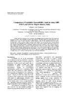 Comparison of Landslides Susceptibility Analysis using AHP, SMCE and GIS for Nilgiris district , India
 The study conducted by S. Shanthi and Dr. K. Elangovan focuses on landslide susceptibility analysis in the Nilgiris district of India using Geographic Information Systems (GIS), Analytical Hierarchy Process (AHP), and Spatial Multi-Criteria Evaluation (SMCE). It identifies past landslide locations and relevant predictors such as geomorphology, geology, and rainfall, creating a landslide inventory map. Using AHP and SMCE, the researchers calculated weights for these predictors, generating a landslide susceptibility (LS) map categorized into five zones. The results showed that SMCE provided a more accurate representation of susceptibility zones compared to AHP, with both models validating well against historical data.
-
 Need and Urgency of Landslide Risk Planning for Nilgiris District
 Landslides pose a significant natural hazard in hilly regions, affecting about 15% of India's land area, particularly in the Nilgiri district of Tamil Nadu, which is highly prone to such events. Historical data shows that unprecedented rainfall has triggered numerous landslides, resulting in loss of life and extensive property damage. The urgent need for effective landslide risk planning is emphasized, advocating for hazard recognition, risk assessment, and the development of appropriate management strategies. Comprehensive hazard mapping and improved infrastructure development are necessary to mitigate risks and enhance public safety in these vulnerable areas.
-
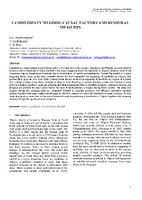 LANDSLIDES IN NILGIRIS: CAUSAL FACTORS AND REMEDIAL MEASURES
 Landslides in the Nilgiris region of India pose significant hazards, affecting around 15% of the area, primarily triggered by heavy rainfall. Factors contributing to these landslides include improper slope excavation, excessive loading at the slope crest, blocked drainage systems, and vegetation removal. Past instances, particularly the devastating landslides in November 2009, resulted in loss of lives and substantial infrastructure damage. The study suggests that while retaining walls are commonly used, implementing cost-effective subsurface drainage systems and slope reinforcement measures could better mitigate these risks. Ongoing research aims to enhance understanding of landslide mechanisms and develop effective, site-specific remedial strategies.
-
 SLOPE STABILITY ANALYSIS OF KALLAR-COONOOR HILL ROAD STRETCH OF THE NILGIRIS
 The study analyzes slope stability along the Kallar-Coonoor hill road in the Nilgiris, a region prone to frequent landslides due to factors like heavy rainfall, steep slopes, and inadequate drainage. Researchers conducted geotechnical assessments at 32 locations, measuring soil parameters such as density, cohesion, and internal friction. They utilized both conventional methods and a Back Propagation Artificial Neural Network (BP-ANN) to predict the factor of safety for slope stability. The BP-ANN approach demonstrated a higher accuracy (85.7%) compared to the conventional method (71.4%), emphasizing its effectiveness in assessing landslide risks and the necessity for slope protection measures in vulnerable areas.
-
 Rainfall Analyses of Coonoor Hill Station of Nilgiris District for Landslide Studies
 The study analyzes rainfall patterns at Coonoor Hill Station in the Nilgiris District to assess their impact on landslide occurrences over 80 years (1935-2013). Findings indicate an increase in annual rainfall, averaging 1773 mm in recent decades, with significant variability during pre-monsoon and monsoon periods. Extreme rainfall events, particularly during the North-East monsoon, are linked to landslides, with 200 mm or more triggering substantial landslide activity. The research underscores the need for effective monitoring and preventive measures in the region, highlighting the dynamic nature of rainfall thresholds for landslide susceptibility influenced by local terrain conditions.
-
 The Nilgiris: Landslide Prone Zones and Human Influence on the
Modification of Hill Environment using Geospatial Technology
The Nilgiris: Landslide Prone Zones and Human Influence on the
Modification of Hill Environment using Geospatial Technology The study examines the impact of human activities on landslide-prone areas in the Nilgiris district of Tamil Nadu, India, highlighting that economically vulnerable populations face the greatest risks from landslides. It emphasizes the need for better urban planning to avoid development in high-risk zones and improve awareness of landslide hazards among communities and policymakers. The research employs geospatial technology to map landslide occurrences and assess environmental modifications from 1990 to 2010. The findings indicate that improper land use, deforestation, and increased settlements exacerbate landslide risks, necessitating a comprehensive risk management strategy to protect the fragile ecosystem and its inhabitants.
-
 Landslip-InstitutionalMapping
 The institutional framework for disaster management in India is structured at national, state, and district levels, with the central government supporting state efforts. Key decisions are made by top bodies like the Cabinet Committee on Security and the National Crisis Management Committee, overseeing disaster responses and resource allocation. The National Disaster Management Authority (NDMA) formulates policies and coordinates their implementation, while state authorities, such as the State Disaster Management Authority (SDMA), develop local plans and training. Local organizations and authorities play crucial roles in community preparedness, response, and recovery efforts, emphasizing a collaborative approach to disaster management.
-
 Landslide_risk_management
 Landslide risk management in India involves the assessment and zoning of areas based on their susceptibility to landslides, using methodologies like GIS analysis to prioritize factors such as slope and rainfall. Historical studies have highlighted the impact of human activities, like construction and deforestation, on landslide occurrences, particularly in regions like Nilgiris, which experienced severe landslides in 2009 due to heavy rains and unsafe development practices. Recommendations for improving safety include stricter zoning laws, enhanced monitoring of rainfall and slopes, and comprehensive planning to avoid future disasters in high-risk areas.
-
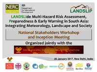 LANDSLIde Multi -Hazard Risk Assessment
 The LANDSLIP project, launched at an inception meeting on January 20, 2017, in New Delhi, aims to enhance multi-hazard risk assessment and early warning systems for landslides in South Asia, particularly focusing on India and Afghanistan. The consortium comprises experts from nine organizations across India, Italy, and the UK, and seeks to integrate meteorology, landscape dynamics, and societal factors into its methodologies. Key objectives include developing tailored risk assessment tools, enhancing communication with stakeholders, and ensuring sustainability through knowledge sharing and capacity building in pilot areas like Darjeeling and Nilgiris.
-
 FOUNDATION FOR ECOLOGICAL SECURITY NET PLANNING IN NABARD WATERSHED
 The "Source Book for Net Planning in NABARD Watershed" serves as a comprehensive guide for planning soil and water conservation measures within NABARD-funded watersheds. It outlines the net planning process, including data collection, technical surveys, and the creation of treatment maps, all aimed at facilitating project proposals during the Capacity Building Phase. The guidelines detail the parameters for assessing land capability and provide simplified formats for easy data recording by field staff. Additionally, the document includes specific structural recommendations for various soil and water conservation interventions, manpower requirements for different project stages, and essential documentation needed for effective watershed management.
-
 Cultivated food of The Nilgiris_Tamil
 The Nilgiris district, part of the Nilgiris Biosphere Reserve, features diverse ecological zones that influence agricultural practices. Historically, shifting agriculture gave way to mixed cropping systems, which enhance biodiversity and support local diets. Key cultivated crops include millets, pulses, vegetables, and grains, often grown using traditional methods without chemical inputs. The community also relies on a variety of uncultivated edible plants, with extensive knowledge of over 70 species used for nutrition and medicinal purposes. These practices contribute to local food security and cultural heritage, emphasizing the importance of sustainable agricultural techniques in this region.
-
 Springshed Management Training Curriculum
 The Springs Initiative's training curriculum includes a case study on the ecological restoration of Happy Valley, a wetland in Nilgiris managed by the Keystone Foundation. Established in 2006, this area serves as a vital water source for local households but faced significant degradation due to encroachment and pollution. Restoration efforts included planting native species, creating a nursery for local plants, and engaging the community through educational activities and waste cleanup. By 2015, the restoration showed positive results, with increased biodiversity and improved water levels, demonstrating the benefits of community involvement in environmental management.
-
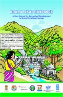 DHARA VIKAS HANDBOOK A User Manual for Spring shed Development to Revive Himalayan Springs Government of India
 The Dhara Vikas Handbook is a comprehensive guide by the Government of Sikkim, aimed at reviving Himalayan springs through springshed development. It highlights the critical impacts of drying springs on communities, particularly women, who face water scarcity due to climate change and increased demand. The initiative focuses on enhancing groundwater recharge via strategies like artificial recharge structures, sustainable land use, and community engagement in resource management. It outlines an eight-step action plan for implementation, including resource mapping and baseline studies, to ensure the sustainable revival of springs and improve rural water security in the region.
-
 UNWRAPPED_ Exposing India’s Top Plastic Polluters
 The 2021 Brand Audit in India engaged over 1,000 volunteers across 19 states to document plastic waste and identify top polluters, revealing that Coca-Cola, PepsiCo, and Unilever dominate. The audit found that 70% of the 149,985 plastic pieces examined were branded, with multi-layered plastics, which are largely non-recyclable, constituting 35% of the waste. The report critiques corporate practices that externalize waste management costs onto informal waste pickers, who play a crucial role in recycling. It calls for stronger regulations mandating the phase-out of non-recyclable plastics, investment in sustainable systems, and formal recognition of waste pickers to effectively tackle the plastic crisis.
-
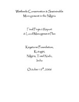 Wetlands conservation and sustainable management in the nilgiri's
 The report focuses on the conservation and sustainable management of wetlands in the Nilgiris, Tamil Nadu, highlighting their crucial role in biodiversity and the livelihoods of local communities, particularly Indigenous groups like the Todas and Badagas. Wetlands, often undervalued and threatened by agriculture and urban development, are essential for water supply and ecological balance. The project involved data collection, awareness campaigns, and the creation of local management plans for five key wetlands, aiming to address pollution, habitat degradation, and stakeholder involvement in conservation efforts. Active restoration activities were initiated to enhance wetland health and community engagement.
-
 Wetlands in the Nigiris_ Report
 The wetlands in the Nilgiris are critical but increasingly endangered ecosystems due to human activities such as agriculture, urban development, and pollution. These ecosystems, often overlooked and seen as wastelands, provide essential services like water supply, biodiversity support, and flood control. The Ramsar Convention has highlighted the need for their conservation since 1971. Studies in the region reveal significant wetland degradation, exacerbated by invasive species and poor land management practices. Conservation efforts, including community awareness and sustainable land use practices, are crucial to restore and protect these vital habitats for future generations.
-
 Development control regulations
 The Indian Institute for Human Settlements (IIHS) has produced 30 cases focusing on urban inclusion through a collaborative research project called 'Reframing Urban Inclusion'. The cases aim to rethink urban theory and practice from India, South Asia, and the Global South. The project has three thematic foci: conceptualizing pro-poor planning, re-visiting settlement upgrading, and addressing slums in India. The cases aim to provide new evidence of possible opportunities and mechanisms for urban integration and build a conceptual and empirical foundation for politically, socially, and economically inclusive cities.
-
 Can peri urban development choose partnerships
 The Indian Institute for Human Settlements (IIHS) is producing 30 cases focusing on urban inclusion. The cases aim to rethink urban theory and practice from India, South Asia, and the Global South. The cases are distributed through open access modes to encourage diverse use and provide a new canon for scholars and educators in the Global South. The project has three thematic foci: conceptualizing pro-poor planning, re-visiting settlement upgrading, and addressing slums in India. The aim is to provide new evidence of possible opportunities and mechanisms for urban integration.
-
 MODEL BILL FOR THE CONSERVATION, PROTECTION, REGULATION AND MANAGEMENT OF GROUNDWATER
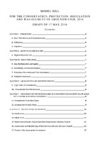
 The 2016 Model Bill for the Conservation, Protection, Regulation, and Management of Groundwater aims to address the ongoing groundwater crisis in India, characterized by over-extraction and contamination, which threatens drinking water security and livelihoods. It recognizes groundwater as a common pool resource and establishes a legal framework to ensure equitable access and sustainable management through local governance structures like Gram Panchayats, urban committees, and councils. The Bill emphasizes the right to safe water, prioritizes groundwater for basic human needs, and mandates comprehensive planning, monitoring, and regulatory measures to protect water resources while promoting conservation and community participation.
