
Items
Tag
Water Resources
-
 Hydrogeology - The Science of Groundwater Hydrogeology is the scientific study of groundwater, focusing on how water moves through geological formations, primarily rocks. Groundwater is a crucial resource, being the largest source of fresh water globally, supplying 85% of rural and 50% of urban water needs. It often exists beneath the surface and can be accessed easily, even in residential areas. This resource acts as a natural filtration system, typically maintaining good quality and stable temperatures. However, groundwater is fragile and sensitive to overuse and contamination, making it essential to understand its properties and distribution through scientific study.
 -
 Remote Sensing in Hydrogeology The Advanced Center for Water Resources Development and Management focuses on understanding water sources such as rain, snow, and glaciers, which melt to form streams. Historically, aerial photography tracked glacier movement, but now satellite imagery is utilized for monitoring. Techniques for measuring snow thickness have evolved from field methods to GPS technology. The interaction of rainwater and meltwater with the ground leads to surface runoff and groundwater recharge, influenced by soil permeability. Additionally, remote sensing helps identify springs, fracture zones, and groundwater features, while thermal and microwave imagery reveal temperature variations and buried structures.
 -
 EARTH SCIENCE IN WATERSHED MANAGEMENT Watershed management is crucial for effective natural resource management, focusing on soil, water, and vegetation within a defined area that drains to a common outlet. It emphasizes the hydrological cycle's role and geographic diversity in managing water resources across various scales, from large regions to micro watersheds. Effective management strategies can enhance water conservation, ensure agricultural productivity, control erosion and sedimentation, and mitigate drought impacts, ultimately supporting water security and food security. Understanding the topography and hydrology of watersheds is essential for optimizing these management practices.
 -
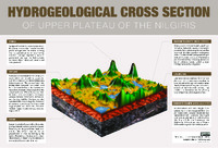 HYDROGEOLOGICAL CROSS SECTION O F U P P E R P L AT E A U O F T H E N I L G I R I S Wetlands are land areas saturated with water, characterized by aquatic plants adapted to the unique hydric soil. They play various roles in the environment, such as water purification, flood control, carbon sinking, and shoreline stability. Wetlands are the most biologically diverse ecosystems, home to a wide range of plant and animal life. The main types of wetland types include swamps, marshes, bogs, and fens. Springs are locations where water from beneath the ground emerges onto the surface, while streams are bodies of water with surface water flowing within the bed and banks of a channel. Laterite is a soil and rock type rich in iron and aluminum, commonly found in hot and wet tropical areas. Charnockites are metamorphic rocks formed by high-grade regional metamorphic processes, often foliated with alternating darker and lighter colored bands called "gneissic banding."
 -
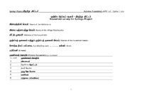 household survey format_V1 The document outlines a structured survey format for the Springs Project, developed by the Keystone Foundation, aimed at assessing various aspects of household water usage, sanitation, and health in Tamil-speaking communities. It includes sections for gathering information on water quality, sources, availability, and sanitation practices, as well as the impact of waterborne diseases on the population. The survey seeks to collect data on household demographics, landholding sizes, primary occupations, and methods of waste disposal, thereby providing a comprehensive understanding of the community's water-related challenges and needs.
 -
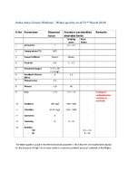 Water_Quality_Anbu Anna Colony_22_March_2018 The document presents an assessment of water quality in the Anbu Anna Colony Wetland, highlighting various parameters measured on that date. It indicates that the water quality is generally good, with most parameters meeting the permissible limits for drinking and river water, except for elevated iron levels, which is a common issue in wetlands in the Nilgiris region. Key measurements include a pH of 7, a temperature of 16°C, and the absence of faecal coliform, while fluoride, dissolved oxygen, and turbidity levels also fall within acceptable ranges. Overall, the findings suggest that while the water quality is satisfactory, attention is needed regarding iron contamination.
 -
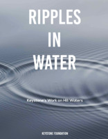 Ripples in Water - Reflections from Keystone's Work on Water in the Nilgiri Biosphere Reserve : 1995 - 2019 This book details Keystone's work on Hill Waters and associated water bodies such as springs, streams, wetlands, etc. Nilgiris itself is a very important catchment area and this book walks us through the major initiatives in Water, undertaken by Keystone, and the learnings and commuity responses from it.