
Items
Tag
geological mapping
-
 GEOHYDROLOGICAL CATCHMENT ASSESSMENT_ BHAMA -ASKHED DAM AND PART CATCHMENT AREA OF CHAS -KAMAN DAM The geohydrological assessment of the Bhama-Askhed Dam and Chas-Kaman Dam catchment areas in Pune, Maharashtra aims to identify vulnerable groundwater recharge zones for infrastructure projects. The study involves geological mapping, drainage analysis, and the development of conservation structure recommendations. Key findings reveal varied geomorphology, with the Bhama river as the primary drainage, and suggest significant recharge vulnerabilities due to disturbances from land-use changes, including windmill installations. The assessment highlights that certain recharge zones are critical for maintaining aquifer potential and emphasizes the need for conservation efforts in these areas to ensure groundwater sustainability.
 -
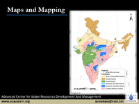 Maps and Mapping The Advanced Center for Water Resources Development and Management focuses on the fundamentals of map-making and geological mapping. Maps are two-dimensional representations of the Earth's surface, requiring scale, reference, and legend for accuracy. Different types of scales include verbal, graphic, and fractional. Latitude and longitude serve as a grid system for precise location identification. Maps can be classified by scale (e.g., cadastral, topographical) or content (e.g., agricultural, climatic). Geological mapping involves understanding various rock types—sedimentary, metamorphic, and igneous—along with techniques like strike and dip for visualizing rock formations. The Global Positioning System (GPS) aids in navigation and location services.
 -
 Regional hydrogeology of the Tendong Hills and a rapid hydrogeological assessment for Kitam The report discusses the complex hydrogeological dynamics of the Tendong Hills and Kitam area in Sikkim, highlighting the interplay of diverse rock types and structures that influence the region's aquifers and spring systems. It emphasizes the importance of incorporating geological insights into watershed and spring development programs to enhance water security, especially in light of climate change and human activities. ACWADAM is actively involved in developing hydrogeologically informed recharge strategies for springs in these areas, aiming to improve water management and community capacity building. The report also outlines specific recharge areas and spring characteristics, underscoring the need for careful monitoring and management to ensure sustainable water supply.